
Geophysicists at KAUST assess “doublet” earthquake phenomenon in Turkey

Asphalt road shows earthquake damage. Photo: Raditya / Shutterstock
On Monday, February 6, 2023, residents in southeastern Turkey and northern Syria were awoken in the early hours by intense shaking. A magnitude 7.8 earthquake had occurred on the East-Anatolian Fault (EAF) system that forms the plate boundary between the Arabian tectonic plate and the Turkish (Anatolian) plate.
Shaking due to this massive earthquake was felt over a huge area — from Cairo, Egypt in the south, to Istanbul, Turkey and Tbilisi, Georgia in the north, and to Baghdad, Iraq in the east, with the duration estimated to have lasted one to two minutes. The intense shaking of the earthquake leveled houses, infrastructure, and entire apartment blocks, causing widespread damage and several thousand fatalities, at the time of writing.
Only nine hours after the magnitude 7.8 shock, another strong earthquake of magnitude 7.7 occurred about 100 km north of the first one, rupturing a separate fault that connects to the EAF system. Given its size and location on a distinctly different fault, this second earthquake was not an aftershock — a series of smaller earthquakes that can occur after the main earthquake — but rather a separate triggered earthquake. Both events form a so-called "doublet" of two strong earthquakes, bringing havoc to the region's population, infrastructure, and economy.
The research groups of Earth Science and Engineering Professors Sigurjón Jonsson (the Crustal Deformation and InSAR Group) and Paul Martin Mai (the Computational Earthquake Seismology (CES) research group) at King Abdullah University of Science and Technology (KAUST) have teamed up for a rapid-response research effort to investigate this unique earthquake doublet in Turkey.
The KAUST research teams are using advanced satellite-data processing and analyses, as well as seismic-data inference to examine the earthquake rupture process. The National Center for Earthquake and Volcano monitoring (NCEV), operated by the Saudi Geological Survey (SGS), contributes seismic recordings to the databases the KAUST teams have access to via international data centers and from KAUST-installed field instruments in Saudi Arabia.
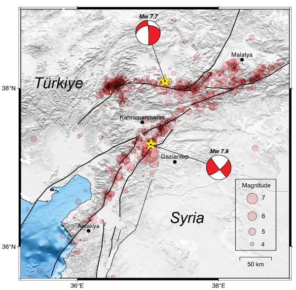
Map of the seismic activity of February 6, 2023, near the Türkiye–Syria border. Fault lines are shown in black. The first magnitude 7.8 mainshock (yellow star) occurred at 01:17 AM (UTC) on the East Anatolian Fault system, The second magnitude 7.7 mainshock (01:24 PM UTC; yellow star) occurred about 100 km north of the first event on a distinctly separate fault. Epicenters of aftershocks are shown by circles scaled by event magnitude. Each mainshock has its own aftershock sequence, whose spatial extent indicates the rupture length. The first mainshock broke along an ~350 km long stretch of the EAF, while the 2nd mainshock was ~170 km long. Graphic courtesy of P. Martin Mai and Sigurjon Jonsson, Earth Science and Engineering, KAUST.
The EAF system continues south and transitions into the Dead Sea Fault system, forming the western border of the Arabian Plate and extending south into the Gulf of Aqaba and the Red Sea. For this reason, Saudi Arabia is exposed to seismic activity. On November 22, 1995, a magnitude 7.2 earthquake occurred offshore Nuweiba in the Gulf of Aqaba, causing substantial damage in nearby towns. Since 1995, only minor earthquakes (magnitude < 5.7) have been recorded in the Gulf of Aqaba, but evidence is accumulating that earthquakes of magnitude ~ 7.5 may have occurred in the gulf in the past.
According to Professor Mai, if earthquakes happened in the past, they will happen again, because the inner deep "earthquake machine" that tectonically loads the fault system does not stop. For this reason, earthquake monitoring, seismic hazard assessment, and civil protection plans are key.
"It is impossible to predict earthquakes; it is also impossible to prevent them. Therefore, we must prepare for them," he said. "Research at KAUST uses seismic, geodetic, and other geophysical and geological data to measure seismic activity and tectonic motions. These data are then used for seismic hazard assessment which may inform seismic safety and national building codes."
Mai added that KAUST scientists also conduct in-depth data analyses and large-scale simulations to estimate the potential shaking in future earthquakes, for instance for the seismically active Gulf of Aqaba region. These combined scientific efforts support urban planning and seismic-safe design in earthquake-prone areas.
Related links
- Under pressure — modeling human-induced earthquakes
- Seismic data yields different quake knowledge
-
Earth Science and Engineering, KAUST