
As above, so below: Remote sensing tools further carbon research
The KAUST Hydrology, Agriculture and Land Observation Lab (HALO) is a techie’s paradise, with shelf and floor space brimming with remote sensing instruments and calibration tools of every size, shape and color used for gathering and validating data in the field, in this case, three mangrove study sites in the KAUST Nature Conservation Area.
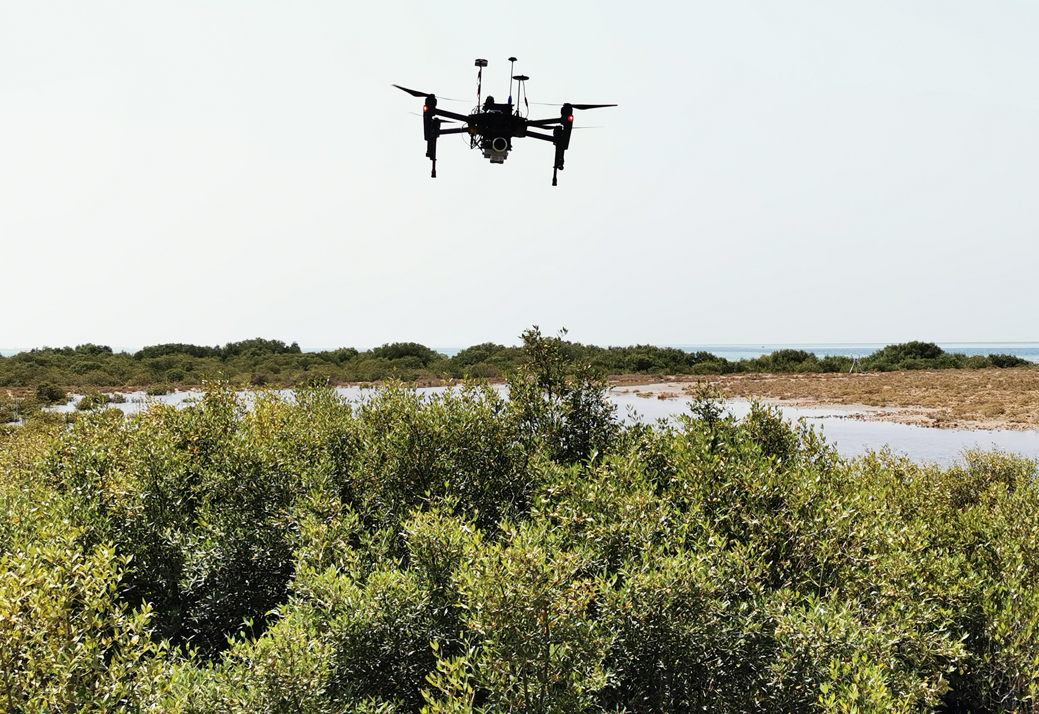
“This is a multirotor, DJI Matrice 100 drone,” said Kasper Johansen, a remote sensing image analyst and HALO research scientist. “We use it to take thousands of photos of the mangrove canopy from multiple angles, which we stitch together to create a high-resolution 3D model and multi-spectral orthomosaic of our sites.”

Drones are among the many remote sensing instruments found in the KAUST Hydrology, Agriculture and Land Observation Lab (HALO) used to collect data in mangrove ecosystems and diverse agricultural sites. Photo: KAUST
A self-professed tech enthusiast who loves to fly drones, Johansen works with a team under the direction of Matthew McCabe, KAUST professor of remote sensing and water security, and director of the Climate and Livability Initiative. A core focus of the HALO team is to use remote sensing tools to map and monitor agricultural sites for plant health, water consumption, evaporation, irrigation amount and various other conditions — information that can be used to improve crop management, water security and food resilience. One of these sites is in Al Jouf at one of the largest olive farms in the world. The scientists also work closely with the Ministry of Environment, Water and Agriculture of Saudi Arabia at various agricultural sites across the Kingdom, and collaborate with other KAUST researchers on vegetation-related research, such as monitoring quinoa and tomato plants in collaboration with the Center for Desert Agriculture.
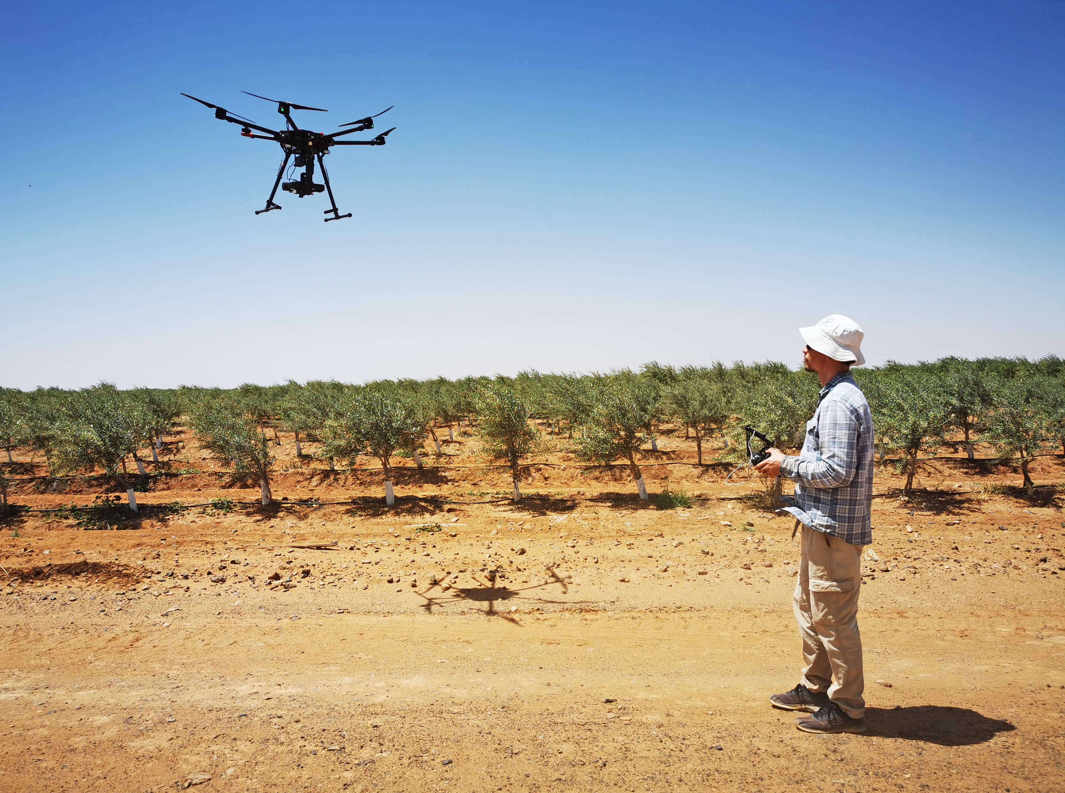
Kasper Johansen, KAUST research scientist and remote sensing image analyst with the Hydrology, Agriculture and Land Observation Lab (HALO), flies an M600 drone above olive trees to monitor plant health and water usage. Photo: KAUST
The mangrove project is unique from these other surveys for its focus on carbon sequestration. Mangroves absorb more carbon than any other terrestrial ecosystem, including rainforests. The HALO scientists work with Avicennia marina mangroves, the predominant species in the Red Sea; their research seeks to determine how much carbon from the air these trees actually capture, and how much they might store.
Offsetting carbon in the atmosphere to offset the impact of other carbon-producing activities is a global priority, and healthy mangrove systems are one way to contribute to carbon neutrality. The more that is known, the more that can be done to promote and conserve these ecosystems. Working with a team of KAUST faculty, the project forms part of the KAUST Circular Carbon Initiative, exploring an aspect referred to as Nature Based Solutions. This is part of a broader effort to support the Kingdom of Saudi Arabia’s conservation and afforestation goals, which include mangroves along the Red Sea and east coast of the country.
The M100 is equipped with a multispectral camera with ten bands covering the red, green and blue (RGB), red edge and near infrared portions of the electromagnetic spectrum. The scientists exploit different wavelengths based on what they want to learn about the mangroves, such as forest density, size and height, and chlorophyl, carbon and nitrogen content in leaves. The drone also has a small sensor for measuring the amount of incoming light from the sun for radiometric correction of the images.
“Picture healthy green vegetation,” said Johansen. “Healthy plants reflect green and particularly near infrared light, while absorbing blue and red light, which indicates chlorophyll absorption in the leaves. Therefore, the analysis of a plant's reflectance characteristics can provide useful information on plant condition and productivity.” The greater the number of bands — some hyperspectral drone cameras have up to 270 — the more refined are the retrieved reflectance characteristics of the mangroves, which may be used to support and facilitate the mapping of biophysical and biochemical properties of the trees.
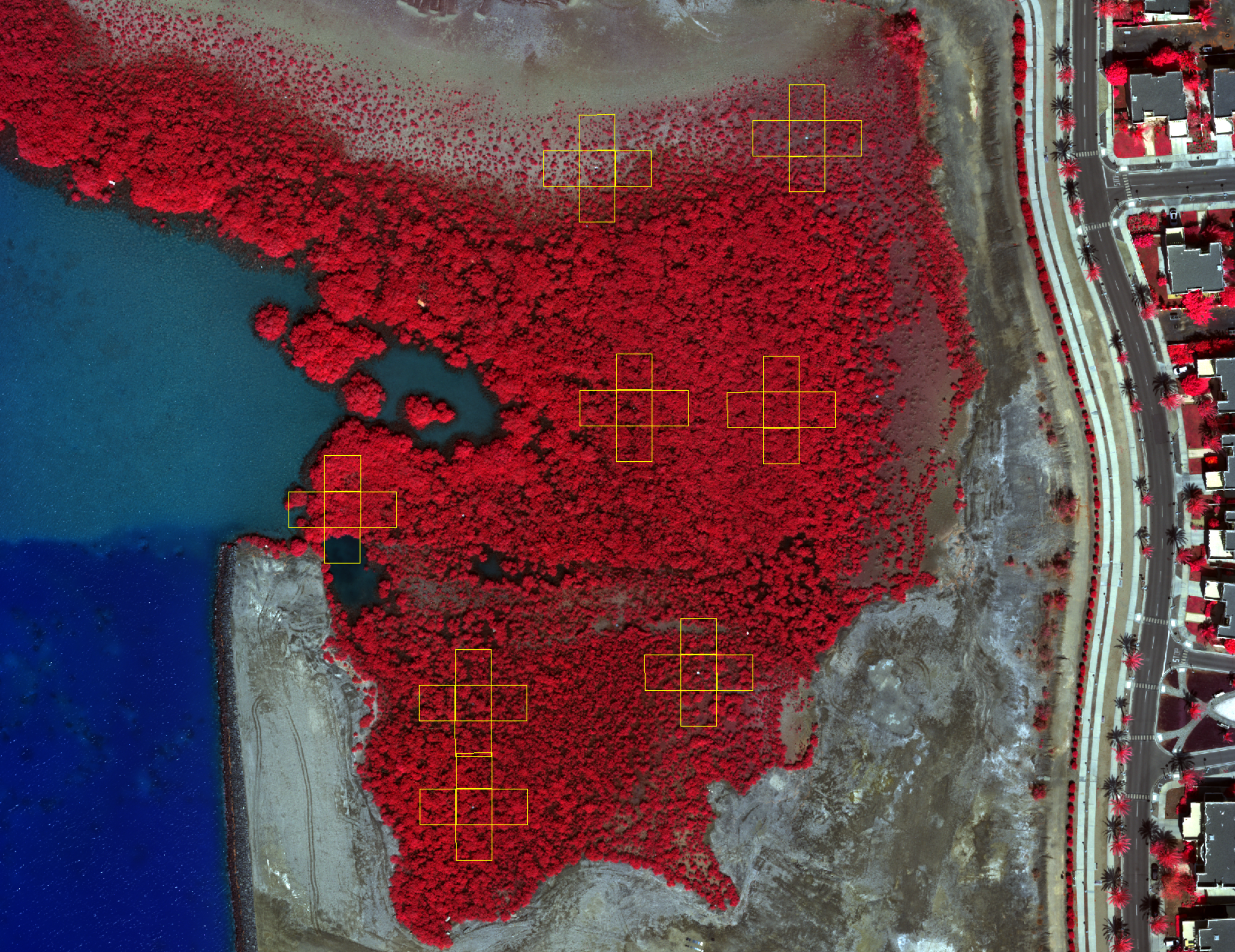
Unmanned aerial vehicle (UAV) orthomosaic of a mangrove site at KAUST where the HALO team works. The near infrared band is displayed as red, the red band as green, and the green, as blue. The mangroves appear red because the near infrared reflectance is much higher from the mangrove trees than the light reflected in the red and green parts of the spectrum.Photo: KAUST
Johansen programs the M100 to follow a pre-determined flight path over a selected site, generally in a pattern of overlapping, parallel flight lines. The resulting point cloud of images and subsequent 3D orthomosaic yields true-to-scale information about the height and spectral reflectance characteristics of the mangroves below.
Leaf-level precision
Mariana Elias Lara works with Johansen and other HALO team scientists. With an undergraduate degree in biology from the National Autonomous University of Mexico, her background is restoration of aquatic ecosystems and water treatment. She’s pursuing a master’s degree at KAUST in environmental science and engineering, with a focus on carbon capture.
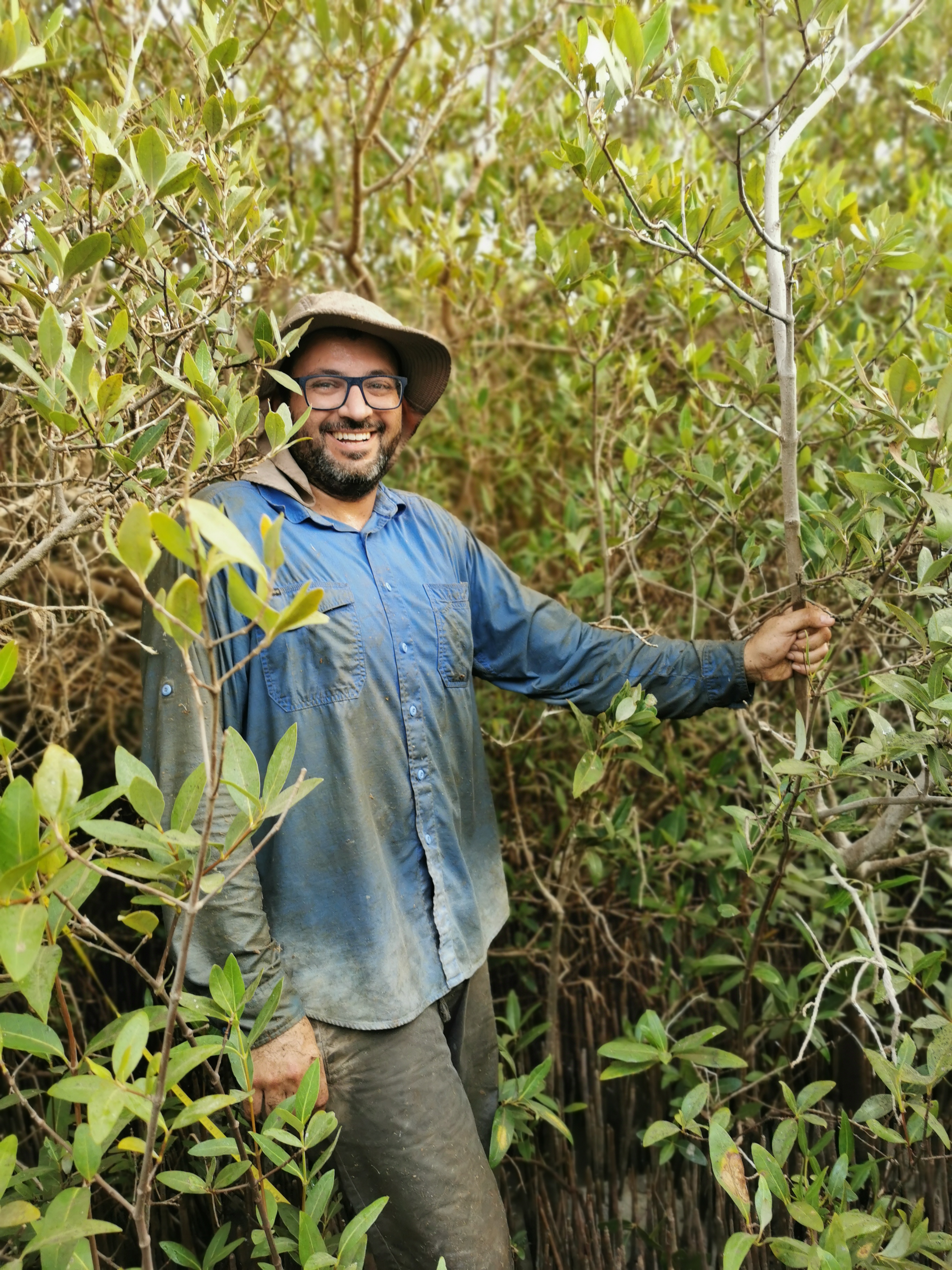
Whereas the Matrice 100 and other drones gather data from the air, the main instrument that Elías uses gathers data from the ground. She spends a lot of time in the mangroves, and conditions can be harsh. The forest is a muddy maze of protruding roots and dense foliage, and the air is typically hot and humid. But it is here, under the canopy, where rich information about carbon can be found.
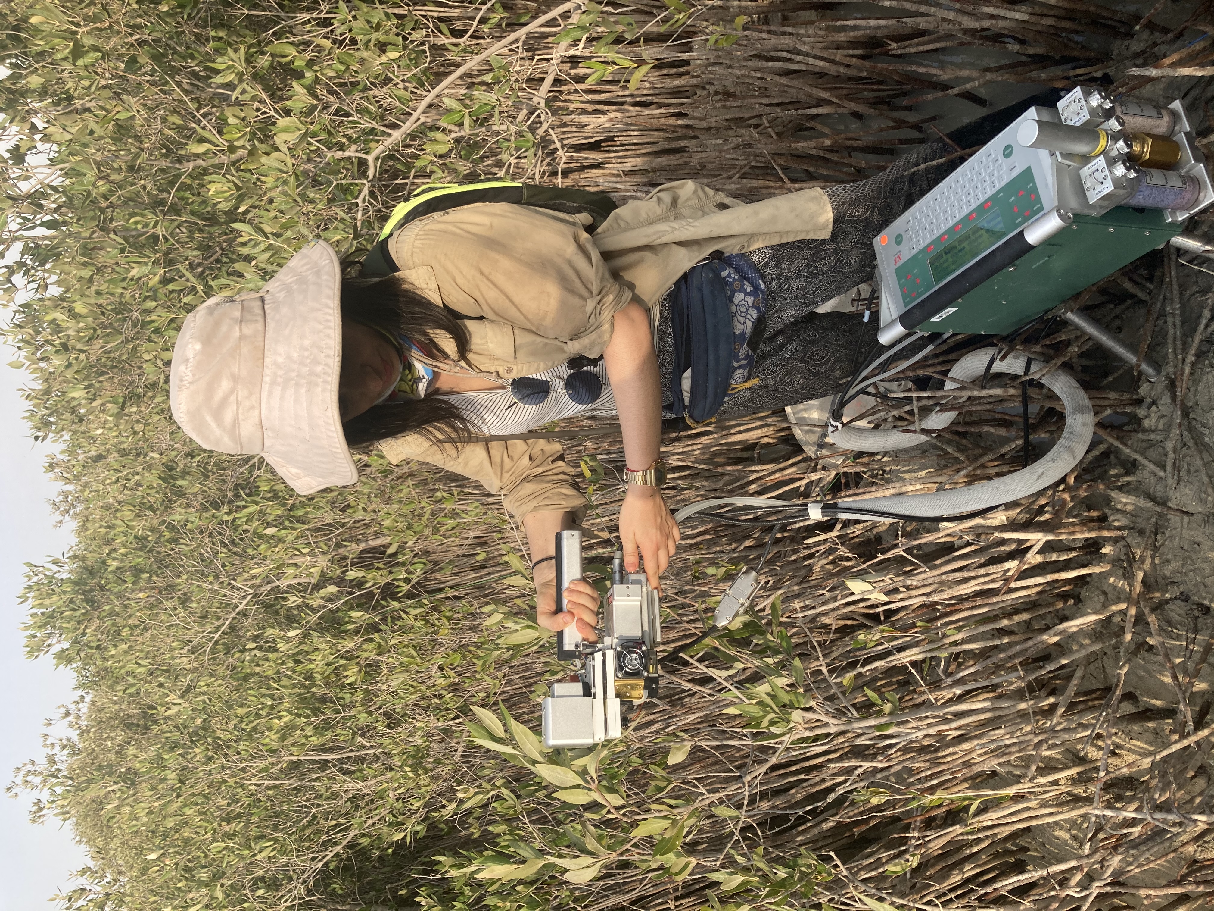
Mariana Elías Lara, KAUST master's student of environmental science and engineering, uses the LI-6400XT, a portable photosynthesis system, to measure gas exchange and estimate the carbon capture of mangrove trees. Photo: KAUST
Elías’s specialty instrument is the LI-6400XT, a portable photosynthesis system for measuring gas exchange. By sampling a representative number of leaves from the trees, the LI-COR instrument can estimate carbon intake for the entire tree based on reading an area as small as two by two centimeters from each leaf. The micro reveals the macro. The instrument shows how much carbon dioxide the leaf absorbs and how much goes out.
The LI-COR instrument works by comparing differential measurements obtained in two parallel cells: the reference and the sample. Air sucked into the instrument passes through filters that absorb carbon dioxide and water from the air. Known CO2 and H2O concentrations pass through the reference cell, while the unknown CO2 and H2O concentrations simultaneously pass through the sample cell, which contains the leaf. The detector compares the amount of radiation passing through both cells, and the signal produced is directly proportional to the difference in CO2 and H2O flux of the leaf.
Elías uses this information to understand carbon assimilation and transpiration — water vapor released by the leaves that affects plant functioning and survival. Repeating this work with a representative sample of leaves from many different trees across the site gives an understanding of variation in leaf CO2 capture values. She clarified that the leaves are but one part of the story.
“Data from the LI-COR instrument are precise but can only be scaled up to the site level by knowing the leaf area index of the individual trees. For this, we need the drones,” she said. “We are building a new model that relates these two datasets so that we can extrapolate across the whole area. And then upscaling from drone data to satellite imagery can give an even greater view from other places in the Red Sea.”
KAUST research scientist Samer Al Mashhawari with the Hydrology, Agriculture and Land Observation Lab (HALO) pauses from a long day of work collecting data in the mangroves, which he and team use to estimate carbon capture and other ecosystem properties. Photo: KAUST
Samer Al Mashhawari, HALO Lab coordinator and research engineer whose expertise is hydrology and evapotranspiration, ensures that all of the equipment works in the lab and in the field. He knows how to run all of them, and how to analyze data on most. He uses another essential instrument in the mangroves — the LI-COR LAI-2200 Plant Canopy Analyzer — to calculate Leaf Area Index (LAI), inferring the total area of tree leaves from the ground to the canopy.
The LAI-2200 uses a fish-eye optical sensor with a 148-degree field of view to measure light levels and light attenuation from five different zenith angles simultaneously, with measurements taken from above and below the mangrove canopy. To get the most reliable estimates, the scientists typically collect data under diffuse light conditions around twilight periods (before sunrise and after sunset) to avoid the influence of direct sunlight.
Although each foliage situation differs based on the random orientation and distribution of leaves, the overall hemispherical image captured by the sensor yields an accurate approximation of foliage amount.
“The timing of measurements is challenging because we want to cover as large an area of the field as possible within the twilight period, which only lasts about 30 or 40 minutes," said Al Mashhawari. "Most of the time we have to wait until sunset for the second twilight period to collect the remaining measurement, which makes it a long day in the field.”
By marking the LAI site areas in advance, Al Mashhawari and scientists can accurately identify these areas in the drone imagery for comparison, and produce a map based on the relationship between the two datasets. Adding the third dataset of known carbon captured at the leaf level, they can convert the LAI map into another map that approximates how much photosynthesis takes place within the imaged area. With the aid of both drones and satellites, that information can be upscaled across a much larger area to get a better understanding of spatial variation and regional level carbon sequestration.
Future applications
The combined remote sensing derived data from drones, ground measurements and satellites help the HALO scientists assess the amount of carbon capture. Elías said these approaches are complementary and are what make their research unique:
“The research we are doing here at KAUST is innovative because no one has related data from the LI-6400XT and LAI-2200 instruments to data from drones. Taking measurements directly from the trees is the more common approach. Our approach could yield scalable data for a better understanding of carbon capture.”

Mangroves absorb more carbon than any other terrestrial ecosystem, including rainforests. Mariana Elías Lara is pursuing her master's degree at KAUST in environmental science and engineering, with a focus on carbon capture; shown here in mangroves in the KAUST Nature Conservation Area. Photo: KAUST
The information has potential for a range of future applications, including different tree species.
“Mangrove ecosystems are an obvious area to look at from a carbon perspective, but we are also looking at tree crop plantations like olive trees,” Johansen said. “Are they acting as a sink or source for carbon in addition to producing olives and olive oil?”
Once parameters are established based on tree structural measurements from drone and satellite data, i.e., trunk diameter, wood density, height, branch structure, etc., the scientists can develop what’s called allometric equations — relating characteristics across scales — to estimate biomass and associated levels of carbon storage in the area.
Johansen clarified that carbon producing activities in the case of tree plantations must also be factored, such as fertilizers, irrigation, harvesting, pruning and transport, which could be calculated against carbon capture to estimate actual gain.
The HALO team is exploring how this data might also be applied to factor carbon loss from activities such as coastal construction in mangrove habitat. Mangroves buffer shores from storms, prevent erosion, provide habitat for marine life and livelihood for fishing communities. Clearcutting mangroves is a huge problem worldwide for the loss of these benefits, and because it releases a large amount of stored carbon dioxide into the atmosphere.
“If we have an approach for mapping carbon capture for mangrove ecosystems, then we can estimate impact,” he said. “The idea is to show what is gained through their protection so that policymakers can legislate accordingly.”
Soils are incredibly important for mangrove ecosystems, as they store the largest amounts of carbon. In collaboration with KAUST professors Daniele Daffonchio and Carlos Duarte, another project involves analyzing carbon content in the soil in relation to tree density to see if carbon soil content varies across the different habitats. Tree age and density mapped from drone imagery might be used as an indicator of soil carbon content.
An ambitious project underway by KAUST postdoctoral researcher Javier Blanco Sacristan uses satellite imagery to map the extent of mangroves in the entire Red Sea. A team of researchers, including KAUST professor Ibrahim Hoteit, is comparing differences between the existing maps and new data gathered to determine areas previously unmapped or underestimated. The model also includes various inputs about where mangroves could potentially grow, factoring conditions such as elevation, tidal inundation, water temperature and different kinds of substrate, from silt clay to sand flats.
To this Johansen said, “The great thing about mangroves is that they do not require irrigation or fresh water. I’m excited by the prospect of this research being applied, and demonstrating the benefits and value from it, which could make a difference in both policy and the way in which countries manage the environment.”